MESA Connector: ION - NORSAR Collaboration
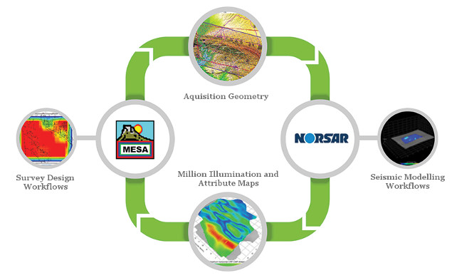
The MESA Expert - NORSAR-3D Connector provides clients with a unique, complementary and seamless capability to validate coverage of survey designs through exclusive illumination workflows based on seismic modeling. This new streamlined seismic acquisition and modeling routine, increases efficiency when designing surveys while decreasing chances of errors due to data transfers.
MESA Expert, provides tools to design, analyze and cost seismic surveys with functionality that includes: advanced geophysical attribute analysis; land, marine and OBS design tools; management of multiple projects; map projection definition and translation; and import/export of industry GIS formats. 3D visualization assists in spatial interpretation of attribute diagnostics. MESA Expert incorporates all of the features of MESA Professional with the additional ability to create subsurface illumination attributes through flexible and straightforward geologic model building and ray tracing.
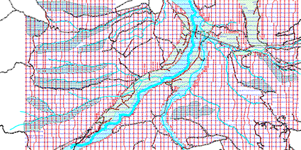
NORSAR-3D is the most advanced product on the market for seismic illumination studies and model-based survey evaluation and analysis. The package is also used on a full industrial scale for generation of travel time maps for Pre-Stack Depth Migration (PSDM). The anisotropy option within NORSAR-3D upgrades the software package to enable TTI anisotropy to be included in layered models. This option enables a more realistic earth model to be constructed, resulting in e.g. an improvement in travel times for PSDM and tomography applications.
NORSAR-3D uses the Open Ray Model representation to simplify model construction. The technology even allows seismic ray tracing in preliminary or incomplete depth models. The new NORSAR-3D is available in three different configurations: Basic, Pro and Expert.
Click here to read the Data Sheet.
Contact details
![]()
iongeo.com
MESAsupport@iongeo.com
![]()
norsar.no
sales@norsar.com